Kaza Spiti
Kaza is the subdivisional headquarters of the remote Spiti Valley in the Lahaul and Spiti district of the state of Himachal Pradesh in the Western Himalayas of India. Spiti, which is a part of the Lahaul and Spiti district of Himachal, is a high altitude or cold desert having close similarities to the neighbouring Tibet and Ladakh regions in terms of terrain, climate and the Buddhist culture. If one has arrived at the Himalaya to hike across ..


Description of Kaza Spiti
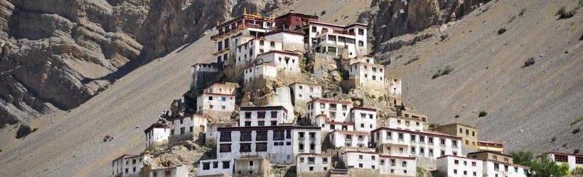
Kaza is the subdivisional headquarters of the remote Spiti Valley in the Lahaul and Spiti district of the state of Himachal Pradesh in the Western Himalayas of India. Spiti, which is a part of the Lahaul and Spiti district of Himachal, is a high altitude or cold desert having close similarities to the neighbouring Tibet and Ladakh regions in terms of terrain, climate and the Buddhist culture. If one has arrived at the Himalaya to hike across high passes and vast tree-covered mountainsides, one will be spoiled for choices in Lahaul and Spiti region of Himachal Pradesh. The old trade route to Ladakh and Tibet may have been tarmacked.
History of Kaza Spiti
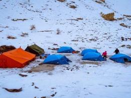
The Spiti Valley is a cold desert mountain valley located high in the Himalaya in the north-eastern part of the Indian state of Himachal Pradesh. The name "Spiti" means "The Middle Land", i.e. the land between Tibet and India.
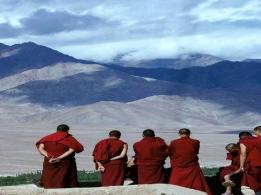
Local population follow Vajrayana Buddhism similar to that found in the nearby Tibet Autonomous Region and the Ladakh region of India. The valley and surrounding region is one of the least populated regions in India and is the gateway to the northernmost reaches of the nation. Along the northern route from Manali, Himachal Pradesh or Keylong via the Rohtang Pass or Kunzum Pass respectively, the valley lies in the North East of the Indian hill state of Himachal Pradesh, and forms part of the Lahaul and Spiti district. The sub-divisional headquarters (capital) is Kaza, Himachal Pradesh which is situated along the Spiti River at an elevation of about 12,500 feet (3,800 m) above mean sea level.
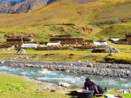
Lahaul and Spiti is surrounded by high mountain ranges. The Rohtang Pass, at 13,054 feet (3,979 m), separates Lahul and Spiti from the Kullu Valley. Lahul and Spiti are cut off from each other by the higher Kunzum Pass, at 15,059 feet (4,590 m). A road connects the two divisions, but is cut off frequently in winter and spring due to heavy snow. The valley is likewise cut off from the north up to eight months of the year by heavy snowfalls and thick icing conditions. A southern route to India proper is periodically closed for brief periods in the winter storms of November through June, but road access is usually restored a few days after storms end via Shimla and the Sutlej in the Kinnaur district.
Geography of Kaza Spiti
Lahoul and Spiti are cut off from the rest of the world because of their high mountain range. Rohtang Pass separates Lahaul and Spiti from the Kullu valley at an altitude of 3,978 meters . The eastern boundary of the district meets Tibet , in the north Ladakh terrain (located in Jammu and Kashmir) and Kinnaur and Kullu are in the south border.
Weather of Kaza Spiti
Kaza is the one of the coldest towns in India. The temperature varies greatly in a different seasons and during a day, January is the coldest period of a year with an average temperature of -45 °C,while the July is hottest month with an average temperature of 10 °C.
Best Time to Visit Kaza Spiti
The ideal time for Spiti to Ladakh Trek is between Mid-June and September of the 2nd week of October (depending on weather conditions)
In Mid June and July:
During these months, one can enjoy cascading waterfalls and beautiful glaciers in the Lahaul and Zanskar valley. The benefit of visiting in during these months is that there will be very less to no rain.
In August, September till mid October: The snow starts melting in May and new plants start to prosper till August giving the opportunity for witnessing Zanskar in one of its most beautiful period.
How to reach Kaza Spiti
By Air
The Kullu Manali airport at Bhuntar Town (about 50 km south of Manali and 10 km south of Kullu town) is the nearest airport, which has flights to Delhi and Chandigarh.
Nearest Railway Station:
Jogindar Nagar is the nearest railway station (lies 166 km from Manali). The other rail heads are at Chandigarh and Pathankot.
By Road:
Manali is well connected by road with Delhi, Ambala, Chandigarh, Dehradun, Haridwar, Shimla, Dharamsala and Chamba/Dalhousie. Regular buses ply between these stations. It is connected with Leh during July to October.